ASTA City of Armstrong Wish List – 2021 & Beyond
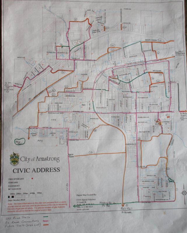
1. Rail Trail towards Enderby
2. Rail Trail towards Vernon connecting the new ‘Sicamous to Armstrong Rail Trail’ with the ‘Vernon Kelowna Rail Trail’
3. Trail from the IPE fair grounds to Mt Rose Swanson via McDonald Road. This would be a tremendous asset to the horse riding community. There are two possibilities:
(1) From the Jackson Avenue trail network to the Deep Creek trail, over to Fraser Road, cross-country to McDonald Road where there is a public easement at the end leading to the crown land and the Mt Rose Swanson Trail network.
(2) Trail beside the sewage treatment plant to Otter Lake Road, through the McKechnie subdivision to Fraser Road, cross-country to McDonald Road where there is a public easement at the end leading to the crown land and the Mt Rose Swanson Trail network.
4. Trail from the end of Jackson Avenue
(1) NE to the IPE fair grounds
(2) SW along the base of a fairly steep hillside and then south to the Chip Trail at Pleasant Valley Secondary School (PVSS). This connects people living in that area with the trail system
(3) North to Deep Creek
5. Trail connecting Rosedale Avenue, West to the Jackson Avenue network
6. Trail from Pleasant Valley Road to Deep Creek
7. Trail continuing along Deep Creek in both directions
(1) Extending E to the railway
(2) Extending W to Wood Ave
- (a) next to Deep Creek through undeveloped land – or
- (b) paralleling the back of the private properties
8. Trail continuing SW along Deep Creek from Adair Street towards O’Keefe Ranch
9. Improved sidewalk from the lights on Highway 97A into Armstrong in both directions
10. Trail from Okanagan Street to the radio tower on Pleasant Valley Road
11. Trail along Highway 97A from Harding Road to the existing trail system descending from Game Court (off Okanagan Street)
12. Trail continuing from Game Court around the Golf Course property
13. Trail connecting Okanagan Street to the Golf Course trail network
14. Trail from the railway tracks following the gulley behind Pheasant Ridge to Colony Street
15. Trail from the top of Highland Park Drive to Schubert Road. This trail would be easy to do as most of it is already owned by the City. The top of the trail levels off and would be a good place for a picnic table.
16. Fenced trail on either side ending at the Coldicott Drive cul de sac (off Murray Drive). It is not owned by the City but there is a possibility that the owner will give permission for it to be used. This trail should be considered for future acquisition as well as the extension of it to Murray Drive as this is a good route to school for students attending Highland Park Elementary School.
17. Trail connecting the two parts of Meighan Creek
18. Trail connecting Hayden Drive
(1) N to Meighan Creek
(2) E to the mall on Smith Drive
19. Trail extending the path along Meighan Creek from Hucaluk Park to Patterson Avenue
20. Five sets of stairs (taken from the Active Transportation Plan) connecting roads for walkers and bikers
(1) From the end Heather Avenue down the bank to Catherine Crescent
(2) From the end of Phillips Street to Catherine Crescent
(3) From the end of Catherine Crescent (at the top of the hill) to the back of the Armstrong Bible Church
(4) From Okanagan Street to Highland Park Drive. There used to be a set of stairs here. Rebuilding them would provide a safer route for people as the roadway has no shoulder for walking.
(5) From the upper Highland Park subdivision to Highland Park Road. These stairs connect people from one area to the other.
The map includes the existing off road trails, on road connectors and future trails (Wish List)

ASTA Township of Spallumcheen Wish List – 2021 & Beyond
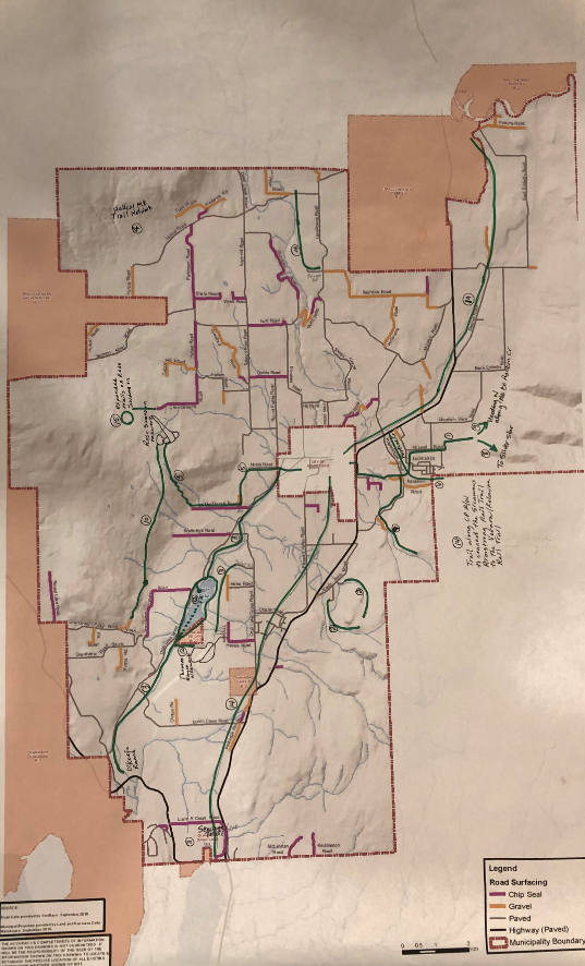
This wish list was started as a result of an ASTS subcommittee meeting with Township staff on 15th January 2020. Our Wish List would be put in their Official Community Plan (OCP) and when development/subdivisions come along that fit in with our wants the Township could act on them. This is definitely long-range planning and certain proposals might not happen.
1. A continuous trail all the way from Memorial Park on Pleasant Valley Road in town to the top of Memorial Mountain – this would incorporate East Rosedale Road to Powerhouse Road across to the McLeod Subdivision. Legal access would be required through private land at the top end of the McLeod subdivision to access the base of Memorial Mtn.
2. Eagle Rock trail
3. Hullcar Mountain Trails – accessed via the BC Hydro right-of-way or other route, and in future, a gateway to Silver Creek, Mt Ida and Salmon Arm.
4. Additional trails on Mt Rose Swanson on the NW side and S to Grandview Flats. This would involve the Back Country Horseman and possibly motor bikers as they currently use the old roads. On the more-used E side of Mt Rose Swanson, there is also an old horse trail going to Round Lake off the Red Loop Trail going W and S.
5. A trail following Deep Creek – from the City to O’Keefe Ranch. Connect to City trail north along Deep Creek. This is something potentially planned by the City when and if they build the dyke along the creek.
6. Trail around Otter Lake. This would mean involving Indigenous peoples and landowners.
7. A trail along Fortune Creek.
8. A trail from Spallumcheen to Silver Star Mountain. Snowshoers have come down from “Silver Queen” (a Sovereign Lake cross-country ski area trail) into the McLeod Subdivision.
9. Trails from Memorial Mtn travelling along the mountain ridges to the N and S. Back country skiers and mountain bikers have gone from Sovereign Lake to Ashton Creek using this route.
10. Develop trails along the ridge directly south of Mt Rose Swanson towards North Grandview Flats Road. Most of this distance is already covered in old skid trails from previous selective logging, or access roads to the abandoned Silica mine there. This area could be accessed from the Red Trail loop on Mt Rose Swanson.
11. Hike up Reservoir Road beyond the locked gate.
12. A trail along the new proposed sewage system route at the south end of Spallumcheen.
13. MacDonald Road access to Mt Rose Swanson.
14. From Scott Park, canoe or kayak Otter Lake south to the bridge on Deep Creek, and then hike east to Thomas Hayes Ecological Park.
15. Connect the ‘Sicamous to Armstrong Rail Trail’ to the ‘Vernon to Kelowna Rail Trail’.
16. Connect the two pieces of Pringle Road.
17. Poplar Drive access to the E side of Otter Lake and then S to Thomas Hayes Ecological Park.
18. CP Railway right-of-way.
